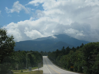
Sunday, August 29, 2010

Bennington, VT and area, August 28, 2010


We were just driving around Bennington and came
across this factory!

The Energizer battery factory in Bennington

Energizer battery factory


All over town there are these life size moose!
They remind me of the decorated bulls in Southlake, TX.

This one is particularly creative!


Another one...


And another. There were many more!
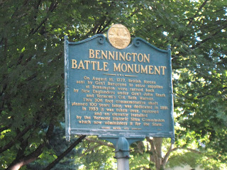

TheBennington Battle Monument is such a tall
tower you can see it on the mountain side from
miles away.


Col. Seth Warner - and the Green Mountain Boys


Col. Warner came in with his (local) Green Mountain
Boys to help Brig. Gen. Stark fight the loyalists and
German mercenaries (who were fighting for England)
in their second battle and were able to defeat the
enemy forces in a turning point victory.


Vernon wanted me to stand by the blocks of
the tower to show how large the blocks are, (or
how large I am compared to the blocks???)


Gen. Stark

This little house is the museum at the Battle
Monument and sits on the site of the Bennington
military storage facility that the British were trying to
overtake.

Bennington Battle Monument


A pretty drive along Historic Highway 7A
near Bennington

Inside the Vermont Country Store, Weston, VT


Collection of old scales at Vermont Country Store

Front of Vermont Country Store in Weston, VT
There have been a couple of places on this trip where we would like to have stayed for a much longer time. This is one of them. There are many scenic drives around here that we would like to have driven - so much to see and do. And the temperatures in August! - we were enjoying 70's and 80's while our friends in Texas were suffering in 107 degree heat. The nights here are in the low 50's and we needed extra blankets at night.
We are definitely planning to come back here and stay for a month or two!

St. Johnsbury, VT to Pownal (Bennington), VT, August 27, 2010


Pine Hollow Campground


Vern telling Ron how pretty the campground is.

Downtown Bennington, VT - such a neat little town!


Bromley, VT, ski and family recreation area


Springfield, VT - I thought the view was interesting -
see the house above the business at the end of the street


The rock cuts along the interstate shown like
silver in the morning sun.


Beautiful hills, but they do a number on gas mileage


I-91 runs along the Vermont/New Hampshire
border
We left Sugar Ridge Campground in St. Johnsbury, VT, about 9 a.m. and drove down
the east side of Vermont, then took Highway 11 west across the state, and Highway 7
on down to Bennington, and on down south a few miles to Pine Hollow Campground in
Pownal, Vt.

Thursday, August 26, 2010

Moncton, NB to Bangor, ME to St. Johnsbury, VT, August 25-26, 2010


Welcome to Vermont


We made it thru with a few inches to spare -
NH/VT state line


Trees are already starting to turn - late August


Mount Washington


Pretty trees in New Hampshire


Welcome to New Hampshire - brake for moose!
We still didn't see one.

Driving thru Maine

Leaving Bangor

We left Bangor about 9 a.m. and drove on highway 2
through Maine and New Hampshire and arrived Sugar Ridge
RV Park, west of St. Johnsbury, VT about 3 p.m.

The road to Bangor, Maine


US Border - the border agent you see on the right is
cuffing a couple from that pick-up and taking them inside.
I'm glad that the worst that happened to us is that they
took our tomatoes and threw them away!


St. Stephen, New Brunswick, the border town


Last pictures of Canada

We left Moncton about 9:30 a.m. and arrived at the St. Stephen/Calais, ME border about 12:30. Drove on highway 9 to Bangor and got there about 3:30, parked in a Walmart parking lot. Light rain in afternoon and during night.

Hopewell Rocks, August 24, 2010


This is a picture of Hopewell Rocks at high tide (found this picture on internet)


Look at the size of these pumpkins - those are
5 gallon sized buckets beside them. On way back
from Hopewell Rocks, we just had to stop and
get a picture of these in a garden by the highway.


Facts on the Hopewell Rocks - the Bay of Fundy
has the highest tides of anywhere in the world - as
much as 53.5 feet depending on the alignment of
the sun and moon to the earth.


Hopewell Rocks


The path we walked down to get to the rocks
about 1/4 mile, then down about 5 or 6 sets of
steps. Of course down was the easy part!


Looking out across the Hopewell Cape at low tide.